A Road Not Taken: The Power of Open Data
Mapping the World & Facilitating Transport Infrastructure

I’m very happy to share this week’s essay with you for two reasons:
It is my foray into writing about tech companies.
The essay is doubly special because it was also my first startup investment(barely a few pounds) when they crowdfunded.
The essay is neither sponsored nor investment advice. I absolutely adore the product and have been an avid user. Let’s get to it.
In today’s essay, we will uncover:
A short note on public transportation.
How Google maps work, for real, the entire backend process!
The mobility experiment of Citymapper: product, business & future!:
Google Maps V/S Citymapper: Answered!
We will start with a history lesson as we always do. The first modern public transportation in the world was created in 1662 by a Mathematician, inventor and physicist Blaise Pascal. It came to be known as carrosses à cinq sols (five-sol coaches).
The type of public transportation used before was largely horse-driven for roads. Boats & ferries dominated the canals. Large carriages were driven by horses on rail tracks for miles. The ferries still hold the dominance but horse carriages came to an end when the horse flu struck in 1872 in New York. It enabled the world to think of better ways of transportation. At that time, omnibuses were also introduced in Paris, London and New York. The 18th and 19th centuries saw the development of cable cars and electric streetcars.
The first commercial flight happened in 1914. In the past 117 years, we have had trains that travel at 300 km/h, flights crossing 1100 km/h, buses, rails, underground metros, hyperloops(coming near you soon) and speed boats. Even if we wonder optimistically, the underground metro and high-speed public transportation would be hard to imagine in the 19th century.
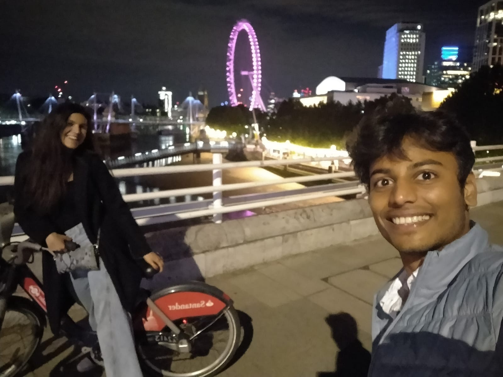
Let me walk you through a thought which I recently had during one of my public transportation experiences. The disparity in public transport between third world countries and first world countries is still monumental. I am from India and I had the fortune of taking the Eurostar four days ago. The train travelled from London, the U.K to Paris, France. The two countries are separated by a sea route called the English Channel.
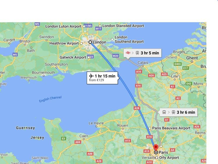
The Chunnel tunnel idea was floated in 1802 but work did not start until 1988 and finished in 1993. It is the world’s longest undersea tunnel spanning 169 Eiffel towers(50.45 km). The experience of travelling through the Chunnel(that’s how it’s called apparently) was exhilarating. Not only piercing through a sea tunnel for the first time but also because Eurostar travels at 300 km/h. It almost feels like the train is floating.
We as human beings have come a long way in building infrastructure for transportation to facilitate mobility from A to B.
The second part of the equation is building experiences and tools to facilitate the infrastructure. The internet comes into play now.
Cities are drastically evolving. The pace is exponential. For instance, have you ever gone back to a place you lived in after a long time(say 5 years)? The map of the place completely changes. New businesses emerge, sky rise buildings pop up, e-scooters parked everywhere and even new roads & highways emerge. It is largely due to increasing population and resource demand. The economic cycle continues.
A thought experiment would be to go back to the 1200s and imagine how many layers have been built to reach the 21st century. It is related to “bone-beds”, which Paleontologists recover to understand history and anthropology. It is how we found dinosaurs too.
How can we keep up with evolving cities, infrastructure, population and their mobility needs?
The Foundation: Open Data
A developed city like London or Paris has at least 5 modes of public transportation spread across the city network like Bus, tube, metro, ferries and a railway network connecting inter-states.
The challenge is to help commuters access the infrastructure with convenience and joy. Enter: Open Data.
Open data evolved from a project, Open Street Map(OSM) in 2004 by Steve Coast.
What is OSM?
It is a project to create a map of the whole world. Cartographers created maps of the sea to help ships navigate enabling trade between countries. Similarly, OSM is a project to map countries, cities, states, roads, addresses and the entire modern world.
The project brought in the big guns with contributions from tech giants like Google and Yahoo providing geospatial data for sharing and usage. It was further complemented in 2010 by Bing who allowed usage of their satellite imagery for the production of maps.
The street views are unimaginably hard to determine using aerial imagery. The data production for the same is done through volunteers who use handheld devices like GPS, video recorders etc. The data makes its way to the database using software tools(eg. Java Openscript). The registered contributors to the open street map project have exponentially grown to nearly one million by 2013. It is fascinating how the whole project works to create the end product: maps. We will explore it further in the section “Understanding Google Maps” below.
I stumbled across a fascinating company while researching open street maps and how data is collected. “Kart View” crowdsources street photographs to aid in improving the OpenStreetMap project. “Kart View” is owned by “Grab” which we popularly recognise as the delivery & payments app and has been making quite a few headlines lately. Grab is the first decacorn(valued > $10 billion). Quite interestingly, a delivery company owns the project for crowdsourcing street views which could colossally aid in logistic solutions.
The application of the OpenStreetMap project is incredible and not just commercial. The Haiti earthquake in 2010 led the government in collaboration with various NGOs to completely map the roads of the entire Republic in less than 2 days.
We can think of OpenStreetMap as a base layer that companies use to build their maps on. For instance, Facebook uses AI & satellite imagery to make up for corrections on the OSM. It is also used by game developers like Ballardia which incorporates OSM in their game engines for game development.
OSM has made accessibility to public transportation incredibly convenient. The open data is leveraged by developers to create brilliant use cases like the Haiti case we discussed above.
At the heart of accessing the mobility infrastructure is Google Maps.
Understanding Google Maps, It’s Fascinating!
Google Maps has its foundation in imagery.
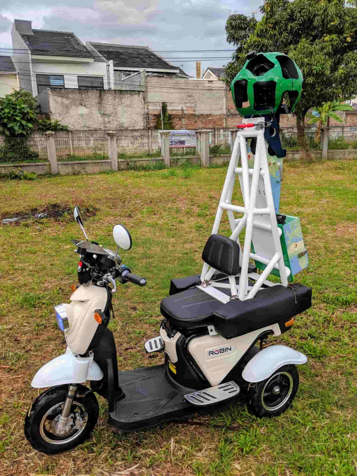
It extracts information like street names, businesses and addresses from high-resolution images which it collects through Street view cars & even three-wheelers at times. The Google Street View project is not limited to Street View cars.
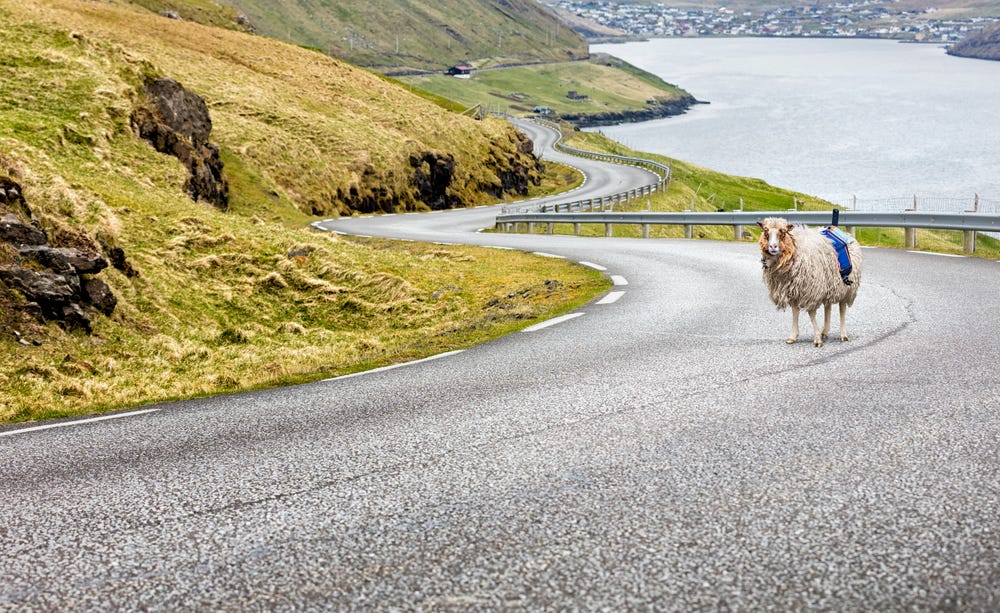
It has leveraged backpacks, kayaks, horses, ships, wheelbarrows and even sheep, yes “SHEEP”!
A picture worth a thousand words is justified by a mere look at the picture of the sheep below. Although, the sheep story is quite fascinating if you want to read further.
Google also collaborates with third-party data vendors like housing developers, geological survey associations along with OpenStreetMaps(OSM project).
The satellite and aerial imagery are used for mapping roads and buildings. The street view further helps in road names, road signs, building numbers and business names.
Along with street view + aerial imagery, Google uses ML algorithms for detection, classification and extraction approaches to identify house numbers and businesses. The way it exactly works is beyond the scope of this essay and frankly, also my understanding.
If you would like to explore further, feel free to read this, this and subsequently this white paper.
Google has further strengthened the mapping ecosystem using User-Generated Data. Local guides, which is an initiative for daily users to participate in map-making. The next time you use Google Maps, look at how you can input data points like crowdedness, accessibility, temperature(strange but important) and security onboard. Google acquired Waze for $1.1 billion in 2014 which helped users to input traffic jams and accident data.
Google My business is leveraged to deliver accurate business addresses and locations to users on the map. It also has a GeoData Upload tool for uploading large amounts of data for NGOs and governments.
Another very interesting feature I discovered in research: Not all houses have addresses in the world(think beyond first world countries).
Google uses “PlusCodes” which is a virtual address allocated to every real-world address in the world. It is based on latitude and longitudes, hence 100% accurate. It can be used in Google Maps, for social security, access emergency services and even for deliveries. My plus code in Paris right now is: R875 + Q6.
Try to find yours, it’s fun.
One of the major features of Google Maps has been live traffic updates which work on GTFS and AI models detailed here.
All of this goes behind the “One-click access to maps”.
It is worth it, otherwise, it wouldn’t have been done. The value vs effort is million fold.
I started writing this essay to talk about one of my favourite startups and my first startup investment. Although, it was imperative to understand the technology behind it to explore the business which we did through “Understanding Google Maps”.
The Mobility Experiment: Citymapper
Citymapper started in 2011 as a “bus mapper”, helping users get access to bus routes. At the time, as Azmat Yusuf describes in an interview with Techcrunch moderator Mike Butcher, “people used to get on the bus and ask the driver where it went”.
These were the times before digital display became commonplace. Mike, who at the time was working at the Mayor’s office in the digital advisory board, jokingly describes that he did have a role in bringing real-time data to the world. The Mayor’s office had advised the Transport for London(TFL) to release the entire transport data to the public. As the open data rolled out, developers set out their horses to build the APIs for mapping public transportation. Thus was born Citymapper.
Citymapper started in London, the most trusted city for public transport which I can personally attest to. Citymapper has leveraged open data to build a product used by more than 50 million users across 80 cities across the world.
The underlying data is pulled from a variety of sources, including open data (usually General Transit Feed Specification (GTFS) files provided by transport authorities) and local transit authorities. Some data is user-generated or collected by locally employed personnel.
We understand now how the data is collected for making the map through the above section on “Google Maps Understanding”, Citymapper uses the same data-driven approach.
How can a small London based startup compare to the Goliath Google Maps? It is not a David vs Goliath story though. Let’s understand.
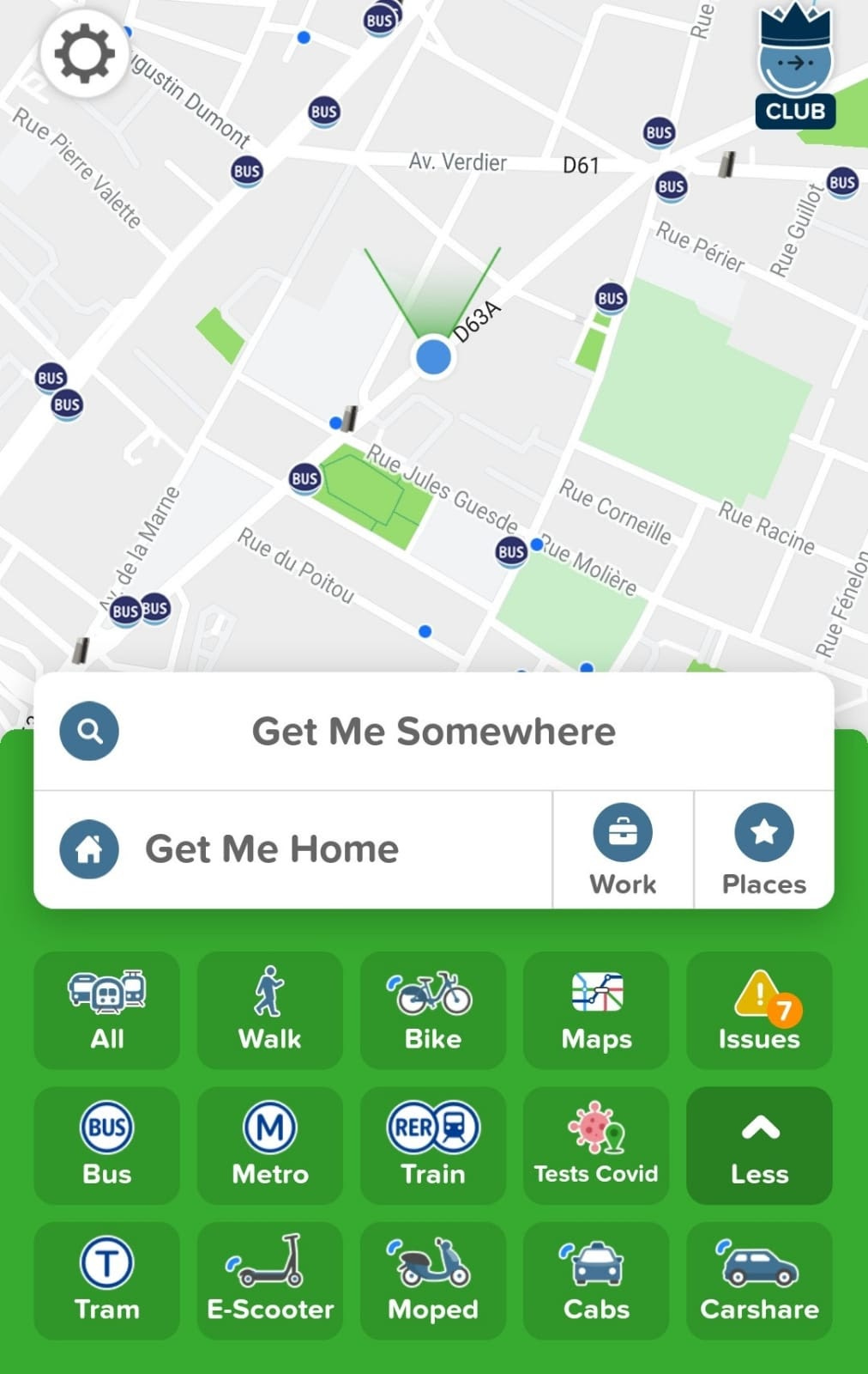
Key Elements of the product:
1. Multimodal
The app combines multiple modes of transportation for ease of use. For instance, it can show halfway through train/bus and the rest through cab/e-bikes etc.
Multimodal not only helps in saving money but also helps in saving time. Although it might not appear so at first glance: the traffic, transport schedule and booking time considered, Citymapper paints the whole picture.
2. Floating Transport
The complexity increases with the introduction of flexible mediums of transport like e-bikes and bicycles for rent.
Floating transport is indeed the future of mobility in mega-cities. It shifts the perspective from “when do we leave” to “where do we leave from anywhere”. Commuters like me who are always late won’t be able to blame it on “bus & train delays”.
3. Real Time changes and fixing the data
Citymapper largely uses open data. One of the disadvantages is the inaccuracies in the system. The train delays and traffic congestions are real-time changes in the transportation ecosystem.
Citymapper is not only leveraging data to create a design product that can be used for commuters, it is also fixing data. At places, the team is also creating data from scratch. It has been largely possible as the startup has created tools to facilitate the purpose. The real-time routing and building data(generating routes) from scratch are done with the help of SuperHero and SuperUsers(early adopters).
For instance, the app in Paris shows the future Grand Paris Express which hasn’t been built yet.
You can refer to this article by Citymapper on medium where they explain how they created the Cross-rails project in London which wasn’t built then.
Business of Citymapper
1. Integrations as an API
APIs: The most powerful tool in the software world. I will be exploring them for next week’s essay.
For now, APIs are a plug which once plugged into an app, gets the superpower of that API functionality.
The best example in the industry right now is Stripe(valued at > $95bn). Upon plugging Stripe API, users of the app can open banking accounts with collaborative banks. It is “banking as a service” in the software world.
Citymapper’s API is used by numerous applications that benefit from the technology they have built.
2. Paid Feature as a Service
Citymapper offers a “club membership” which gives commuters the superpower to access:
TURBO: Routing ranked by speed
SIMPLE: Fewest transfers for A to B commute
PRICE: Cheapest routes and fares
MIXED: Multimodal which we discussed above.
It offers the service at 2.99 euros/month or 19.99 euros/year. The current number of users who have adopted this service is not yet declared publicly.
3. The Fintech Shift: Mobility Pass
The paywave(contactless payments) is an incremental shift in payment technology. It is efficient and saves us the trouble of remembering pins. Post covid, it also saves the effort of pushing buttons on the pin-pad of a stranger’s machine.
It connects to transportation as well. Transport for London (TFL) implemented contactless payments in its entire transportation network. It not only makes travel faster and easier but also opens up the space for private companies to provide services, boosting the facilitation of the infrastructure.
Citymapper came up with “PASS”, a physical card as well as connecting the app to the real world. It launched in London in 2019, providing
A one-stop solution for multiple modes of transportation
Integration between the app and the card.
A bundle offering unlimited tubes, metros, rails and e-scooters. It is lucrative in London because TFL is not very economical.
For instance, a friend of mine spent 216 GBP/month on transportation every month whereas she would have spent 132 GBP if she used the pass.
Although, the strategy has a dependency. It can only work in places where transport systems have contactless payment technology. It is not that common, even Paris does not have it in their public transportation system and it does not appear to arrive for some time in future.
4. Funding & why it’s not Citymapper’s priority
Let’s address the question as to why it is not a David vs Goliath story. If I were to propose funding to Citymapper for $1 billion, they would simply decline it. Why?
It is largely because they are a software company crunching data to build an elegantly designed product for commuters. Their major cost is human resources and servers, not marketing. The source for data is largely OSM and other public transportation agencies.
The venture capital investors who invested in the company in 2014, emphasized their investment in its ability to remove friction & its localization to each city. The belief was that it could become a home-screen app for every urban dweller. The vision has slowly come to become a reality in 2021.
The Big Question: Google Maps V Citymapper
I have been an avid user of Google Maps. At a point in my life, I even aspired to become a local guide and help improve the product. It is not due to my passion for transportation and technology but due to my obliviousness to understand and remember routes.
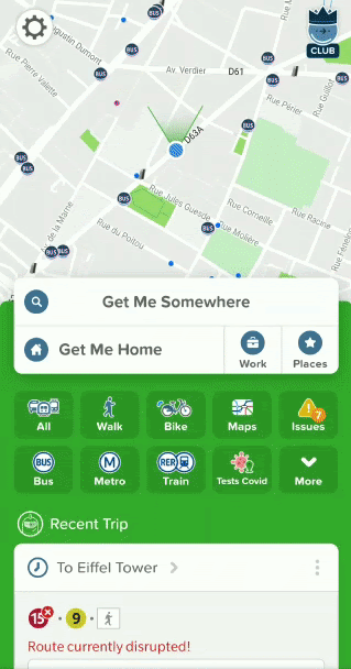
I downloaded Citymapper in February upon reaching London. A person who cannot remember which bus or train to take, it’s a blessing.
Citymapper crowdfunded on CrowdCube and I instantly knew I had to invest. Of Course, being a broke student writing a newsletter doesn’t pay but I invested what I could. From that point onwards, I have got numerous commuters hooked to Citymapper.
I even spoke about it to random strangers at random bus stops who were trying to scan a QR code on the bus stop to view the bus timings.
I say this now because a friend of mine(the same person who spent 216 GBP/month on TFL) asked me what was the difference between Google Maps & Citymapper. She did love Citymapper but it was more of a curious wonderment. At the time, I answered for the sake of it but was myself not convinced.
Upon contemplation: Google Maps is better in terms of algorithm and data, but?
The major difference lies in the intent of the product and localisation.
Google Maps is designed to help mobility in every aspect. The purpose of Citymapper is planning & mobility from A to B leveraging public & private transportation. Features like “Multimodal”(combining multiple modes of transport like Uber & bus) solidifies the intent mentioned above. Google Maps does not boast this feature.
The intent further extends to building routes for local transports which never existed from scratch like Peseros: the buses of Mexico City by Citymapper.
What does Future look like for Citymapper?
What can be done with Data? The possibilities are endless.
Solving congestion issues in the city.
The data of transportation combined with where commuters are travelling to when they are going and frequency of visits can help redesign mobility and cities.
Improving the experience of commuters
Citymapper has been aligning its future with the future of transportation and mobility. It is increasingly focussing on creating tools for urban planning. The startup also aims to make everyday commute a joy rather than a taxing experience.
Citymapper marks my foray into tech essays. I hope you enjoyed it.
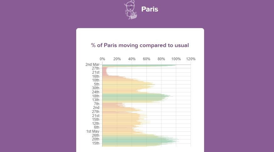
Bonus: Marketing during COVID
Citymapper has a page showing mobility index which represents how movement stopped in a certain city in response to covid restrictions. It is a creative use of data & application of the app to show how efficiently data can be used.
See you in the next one!